Bogotá, Colombia — The meteorological outlook for Colombia through the week of October 19 to 23 presents a stark geographical contrast. According to the latest reports issued by the Institute of Hydrology, Meteorology and Environmental Studies (Ideam), the national territory will experience a dual climate pattern characterized by torrential downpours concentrated primarily in the western regions and parts of the Amazon, running concurrently with notable high temperatures in various northern, eastern, and insular zones.
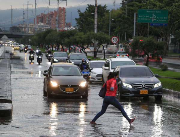
For millions of citizens, this means preparing for frequent disruptions due to heavy rainfall—particularly in historically vulnerable departments like Antioquia, Chocó, Cauca, and Nariño—while simultaneously monitoring heat-related warnings in drier sectors of the country. Urban centers, most notably the capital city of Bogotá, are also expected to see regular precipitation cycles, affecting daily commutes and outdoor activities.
Main Facts: A Dual Meteorological Landscape
The overarching narrative of this week’s weather report from Ideam is the juxtaposition of severe hydrological activity against pockets of elevated thermal readings. While western Colombia bears the brunt of atmospheric instability, the broader weather map highlights localized microclimates that demand vigilance from regional authorities and local populations alike.
The Core Highlights:
- Primary Zones for Heavy Rains: The most intense precipitation is heavily concentrated in the departments of Antioquia, Chocó, Cauca, and Nariño, alongside localized sectors of the Amazon basin.
- Bogotá Forecast: The capital will experience frequent rainfall throughout the first half of the week, with peak intensity expected on Monday, Tuesday, and Friday—particularly hitting the northern and western districts.
- High Temperature Zones: Elevated maximum temperatures will persist across the Caribbean, Insular, Pacific, Amazonian, and Orinoquía regions, as well as the Middle and Lower Magdalena valleys.
- Insular Weather: The archipelago of San Andrés, Providencia, and Santa Catalina will face light to moderate showers, particularly from Monday through Wednesday.
According to Ideam’s expert meteorologists, these atmospheric behaviors are driven by seasonal shifts in moisture convergence coming from the Pacific Ocean and the Amazon basin, interacting dynamically with the Andean cordilleras.

Chronology of the Week: Day-by-Day Forecast
To better understand how the weather patterns will evolve across the country, Ideam has released a detailed daily breakdown spanning Monday, October 19, through Friday, October 23.
Monday, October 19: The Week Begins with Regional Downpours
The week kicks off with significant meteorological activity. Heavy rainfall is anticipated across the Sierra Nevada de Santa Marta, southern Bolívar, Antioquia, and the broader western regions of the country. Coastal areas of Cauca and Nariño are also slated for heavy maritime and terrestrial precipitation.
Concurrently, moderate rains will make their presence felt across central Caribbean zones, Santander, the Coffee Triangle (Eje Cafetero), the Orinoquía, and parts of the Amazon. In Bogotá, the week starts off wet, with showers hitting the capital’s northern and western corridors.

Tuesday, October 20: Intensification in the Northwest and South
By Tuesday, atmospheric conditions tighten over the northwest. Precipitation values are projected to spike significantly in Antioquia and neighboring Chocó. Furthermore, Ideam warns of heavy, sustained downpours expanding across Cauca, Nariño, and deeper into the southern and eastern expanses of the Amazon. Bogotá residents should prepare for another wet day, maintaining an umbrella handy for frequent afternoon and evening showers.
Wednesday, October 21: Persistence Along the Pacific and Cordilleras
Midweek brings little respite to the western seaboard. Heavy rains remain anchored over Antioquia, contiguous areas of Chocó, and parts of Cauca and Nariño. Meanwhile, the Amazon region will experience localized, heavier downpours. Moderate showers are forecast to develop over central and eastern Caribbean sectors, stretching along the Eastern Cordillera and down into the Eastern Plains (Llanos Orientales).

Thursday, October 22: A Shift in Regional Intensity
Thursday marks a slight tactical shift in the national weather map. While the Caribbean and Orinoquía regions are expected to experience a temporary decrease in overall precipitation, heavy storms will concentrate heavily in western Chocó, Valle del Cauca, Cauca, Nariño, and the southern/eastern reaches of Amazonas.
At the same time, moderate rainfall will touch departments such as Atlántico, Bolívar, Sucre, western Antioquia, Boyacá, and Cundinamarca, showcasing a more dispersed distribution of water across the Andean interior.
Friday, October 23: Closing Out the Week with Variable Storms
As the workweek concludes, heavy rainfall is predicted to flare back up in Antioquia and Santander, alongside persistent storms in western Cauca and Nariño.
Moderate precipitation will extend into southern Córdoba, Bolívar, Chocó, the Coffee Triangle, Valle del Cauca, and areas surrounding the Sierra Nevada de Santa Marta. Meanwhile, the eastern plains and Amazonian lowlands will settle into lighter, more scattered showers. Bogotá will see a resurgence of its peak weekly rainfall intensity, wrapping up the five-day cycle with wet conditions in the north and west.

Supporting Data: Temperature Extremes and Regional Variances
While the dominant news cycle focuses on rain accumulation, Ideam’s data emphasizes that Colombia is far from experiencing a uniform climate this week. The coexistence of heavy downpours in the west and high temperatures elsewhere creates a complex management scenario for agricultural and civil protection agencies.
- Dry and Hot Pockets: While much of the nation battles saturated soils, regions such as La Guajira, localized spots along the Eastern Cordillera, and select areas in the south of the country will experience pronounced dry spells accompanied by elevated maximum temperatures.
- Insular Precipitation Window: San Andrés and Providencia will see manageable precipitation, largely front-loaded between Monday and Wednesday, before tapering off toward the weekend.
- Urban Vulnerability: In Bogotá, the concentration of rain in the northern and western sectors points to localized microclimates driven by topographical updrafts against the eastern hills, a classic meteorological phenomenon for the high-altitude capital.
Official Responses and Civil Protection Measures
In light of the forecasted weather patterns, disaster management and environmental authorities have ramped up monitoring efforts across high-risk zones.

Ideam’s Directives
Ideam has urged local departmental and municipal risk management committees (Comités de Gestión del Riesgo) to remain on high alert, particularly in departments like Chocó, Antioquia, Cauca, and Nariño. Because these regions have experienced cumulative rainfall over previous weeks, soils are heavily saturated, drastically increasing the threat of sudden landslides, flash floods, and overflowing rivers.
Recommendations for Citizens
- In High-Risk Zones: Communities residing near mountain slopes or riverbanks prone to swelling are advised to monitor local alerts closely and prepare evacuation routes if necessary.
- Urban Commuters (Especially in Bogotá): Drivers and pedestrians are encouraged to plan commutes ahead of time, keeping in mind that heavy downpours during peak hours frequently lead to localized traffic congestion, water pooling on major roadways, and reduced visibility.
- Agricultural Sector: Farmers in regions experiencing high temperatures alongside sudden heavy rains are advised to adjust crop management strategies to protect sensitive yields from sudden thermal stress and root-rotting moisture levels.
Implications for Infrastructure, Health, and Economy
The predicted climate distribution carries profound implications for multiple sectors of Colombian society:

- Infrastructure and Transportation: The persistence of heavy rains in mountainous corridors—such as those connecting Antioquia to the Caribbean, or routes crossing the Western and Central Cordilleras—poses an ongoing threat of highway blockages due to rockfalls and mudslides. This can temporarily disrupt supply chains, raising transport costs and delaying commercial freight.
- Public Health: Fluctuating weather patterns involving alternating heavy rains and high ambient temperatures historically correlate with spikes in vector-borne diseases (such as dengue, Zika, and chikungunya) in tropical and lowland areas like the Caribbean, Pacific coast, and Amazonia. Health authorities are scaling up vector control campaigns.
- Agriculture and Water Resources: While excess water in western regions threatens crops with saturation and fungal issues, the high temperatures projected for parts of the Caribbean and Orinoquía necessitate careful water resource management to prevent localized drought stress in cattle ranching and agricultural fields.
As Colombia navigates this dynamic meteorological week, citizens are encouraged to stay informed through official updates issued by Ideam and local civil defense channels to ensure safety and preparedness across all affected regions.