By International News Desk
Updated: October 21, 2026
The tropical Pacific region is currently grappling with a severe meteorological event as Super Typhoon Champi, known locally in the Philippines as "Rosal," reaches its peak intensity. The storm, which has been monitored closely by regional weather agencies, currently presents a significant threat to life and infrastructure across the northern reaches of the Philippine archipelago and is projected to exert a heavy influence on the maritime territories near Taiwan.
As of the latest bulletins from the Philippine Atmospheric, Geophysical and Astronomical Services Administration (PAGASA), the super typhoon is packing sustained winds of 215 km/h, with powerful gusts reaching up to 296 km/h. This classification places Champi among the most dangerous storm systems seen in the region this decade, prompting a massive mobilization of emergency services.
The Core Meteorological Facts
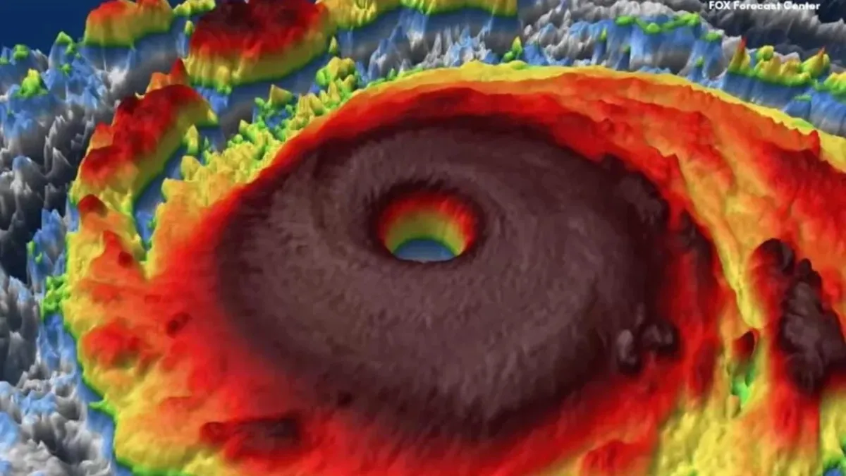
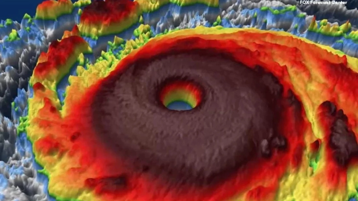
Super Typhoon Champi is a highly organized, powerful cyclone that has intensified rapidly over the warm waters of the Philippine Sea. At 10:00 local time (02:00 GMT), the system was situated approximately 845 kilometers east of the Luzon region. Its rapid strengthening over the last 24 hours has caught authorities off guard, forcing them to quickly escalate warning levels across vulnerable provinces.
Meteorologists classify the system as a "super" typhoon due to its sustained wind speeds, which exceed the threshold for Category 5 status on many global scales. The storm’s structure remains tight and well-defined, suggesting that its destructive potential will remain high even as it begins its transition away from the immediate coastal areas.
Chronology of the Event: From Tropical Depression to Super Typhoon
The development of Champi has been characterized by its explosive growth.

- Initial Formation: The disturbance was first identified as a low-pressure area earlier this week. It showed early signs of rotation and moisture accumulation, which satellite imagery confirmed as a deepening tropical depression.
- Rapid Intensification: Within a 48-hour window, favorable atmospheric conditions—characterized by low wind shear and high sea-surface temperatures—allowed the storm to transition into a full-fledged typhoon.
- Reaching Peak Intensity: By the early hours of Wednesday, October 21, 2026, the storm achieved its "pico de intensidad" (peak intensity). PAGASA officially declared it a super typhoon, noting the extreme wind speeds that now define the system.
- The Current Phase: As of this morning, the system is at its most potent state, moving steadily in a west-northwesterly direction.
Official Responses and Warning Systems
In response to the imminent danger, the Philippine government has activated its multi-tiered disaster response protocol. The shift in alert levels reflects the government’s commitment to minimizing casualties.
The Alert Level System
- Level 2 Alert: This has been issued specifically for the northern province of Batanes. Residents are warned of wind speeds ranging between 62 and 88 km/h. Authorities expect these conditions to persist over a 24-hour window, leading to inevitable damage to homes, widespread power outages, and significant agricultural losses.
- Level 1 Alert: This remains in effect for the northern stretches of the archipelago, including the provinces of Cagayan—encompassing the Babuyan Islands—Ilocos Norte, and Apayao.
PAGASA has been explicit in its warnings regarding the maritime conditions. The agency has reported that waves generated by the storm are expected to reach heights of up to 9 meters in the vicinity of Batanes and the Babuyan Islands. Meanwhile, the eastern Visayas can expect waves reaching 4.5 meters. Consequently, a strict prohibition on maritime travel has been enforced, with all vessels ordered to remain in port.
Socio-Economic and Environmental Implications
The potential impact of Super Typhoon Champi cannot be viewed in isolation; it comes at a time when the region is already reeling from long-term climate instability.

Lessons from History
The memories of 2025 remain fresh for many Filipinos. Last year, the region was devastated by consecutive tropical cyclones, including Typhoon Kalmaegi and Super Typhoon Fung-wong. Those events resulted in more than 200 fatalities and caused immense economic damage, affecting millions of citizens. The trauma from those events has led to a more proactive stance from local government units (LGUs) this year, with earlier evacuations and better-stocked emergency relief supplies.
Agricultural and Infrastructure Vulnerability
The northern Philippines, specifically the Luzon region, is a critical agricultural hub. The projected path of Champi threatens to wipe out seasonal crops, which could lead to food security issues in the coming months. Furthermore, the topography of the region, characterized by mountainous terrain and river valleys, makes the area particularly susceptible to:
- Flash Floods: Due to the expected heavy rainfall that will likely persist through Friday.
- Landslides: The saturation of soil on steep slopes remains a primary concern for authorities, who have already identified high-risk zones and urged residents to move to higher ground.
Future Outlook: The Path Forward
While the current situation is dire, meteorological models provide a glimmer of hope. PAGASA’s forecast indicates that the super typhoon is expected to begin its weakening phase as early as this afternoon.

The projected trajectory suggests a gradual decline in intensity:
- Thursday: The system is expected to be downgraded to a standard Typhoon.
- Sunday: It is predicted to reach the status of a "Severe Tropical Storm" as it exits the Philippine Area of Responsibility (PAR) and continues its track toward the west-northwest.
However, meteorologists emphasize that while these projections are standard, the behavior of a super typhoon can be unpredictable. Slight shifts in the storm’s path or interaction with the mountainous terrain of Taiwan could lead to unexpected variations in wind speed and rainfall intensity.
The Broader Context: A "Without Precedent" Climate
This meteorological disaster occurs against a backdrop of global climate concern. Recent reports from the United Nations have highlighted that current weather phenomena, including the lingering effects of the El Niño cycle, are producing conditions "without precedent." With global temperatures rising to as much as 3.8 degrees Celsius above historical averages in certain regions, the intensity of storms like Champi is becoming the new, dangerous normal.

The resilience of the Filipino people is being tested once again. As the government, international aid agencies, and local community leaders coordinate their response, the priority remains clear: the protection of human life.
Conclusion: Staying Informed
For those in the affected regions, the advice from the authorities is uniform: stay indoors, monitor local news channels, and heed all evacuation orders. Information is the most vital tool in disaster mitigation. Official updates are being broadcast via radio, social media channels, and government websites.
As the region braces for the full brunt of the storm, the global community looks on with concern, hoping that the rigorous preparations made by the Philippine government will succeed in keeping the death toll to a minimum and mitigating the long-term impact of this powerful super typhoon.

The battle against nature’s most extreme forces continues, and as the winds howl across the northern islands, the focus shifts from preparation to survival, and eventually, to the long process of recovery that follows in the wake of such a formidable storm.
Disclaimer: This report is based on information provided by the Philippine Atmospheric, Geophysical and Astronomical Services Administration (PAGASA) and international meteorological agencies. Residents are advised to follow the instructions of local disaster management authorities at all times.