Bogotá, Colombia — In the quiet, predawn hours of Tuesday, November 3, 2026, a strong seismic event jolted millions of residents awake across various regions of Colombia. The earthquake, initially reported as a moderate tremor, was later confirmed by the Colombian Geological Service (Servicio Geológico Colombiano – SGC) to have reached a magnitude of 5.6.
The geological disturbance, which occurred at precisely 4:13 a.m., rattled nerves, sent panicked citizens into the streets, and prompted an immediate response from emergency management networks. While preliminary assessments suggest no catastrophic structural damage or immediate reports of fatalities, the event serves as a stark reminder of Colombia’s complex and active tectonic landscape.
As seismologists continue to monitor the region, authorities have urged calm and reiterated the importance of relying strictly on official channels for verified updates regarding safety protocols and aftershock activity.
1. Main Facts: Core Details of the Seismic Event
According to the definitive bulletin released by the SGC, the earthquake struck with a shallow depth—technically classified as less than 30 kilometers deep—making the energy release far more perceptible to populations residing above and near the epicenter.
Magnitude: 5.6
Date and Time: Tuesday, November 3, 2026, at 4:13 a.m. local time.
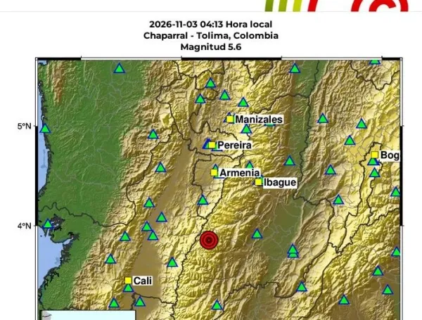
Epicenter: Initially estimated near the municipality of Chaparral, the SGC’s updated coordinates placed the epicenter less than 20 kilometers from the municipality of Roncesvalles, Tolima, at coordinates 3.84 latitude and -75.65 longitude.
Depth: Superficial, estimated at less than 30 kilometers (initial reports indicated approximately 19 kilometers).
Closest Municipalities: Roncesvalles, San Antonio, and Chaparral (all situated within the department of Tolima).
Aftershocks: Five confirmed aftershocks ranging in magnitude from 2.1 to 3.5 within the first hour and a half following the primary tremor.
Because shallow earthquakes release their seismic energy closer to the Earth’s surface, the shockwaves traveled rapidly and were felt with significant intensity across a wide swath of the Colombian territory, including high-density urban centers hundreds of kilometers away from the epicenter.
2. Chronology of the Event and Immediate Aftermath
The unfolding of Tuesday’s seismic emergency followed a rapid sequence of detection, automated alerts, citizen mobilization, and official institutional communication.
4:13 a.m. – The Main Shock: The 5.6 magnitude earthquake strikes deep within the Andean region of Tolima. The sudden, violent shaking abruptly awakens citizens across central and western Colombia.
4:30 a.m. – Initial SGC Reports: Automated monitoring systems and early seismic bulletins from the SGC place the epicenter near Chaparral, Tolima, estimating the depth at roughly 19 kilometers.
4:45 a.m. – First Wave of Citizen Response: Social media platforms and the SGC’s "Sismo Sentido" (Earthquake Felt) portal experience an exponential surge in traffic. Thousands of individuals log on to report heavy shaking in major metropolitan areas like Bogotá, Cali, and Ibagué.
5:15 a.m. – Updated Epicenter Coordinates: Following advanced data processing, the SGC refines its telemetry data, officially shifting the epicenter slightly to encompass the municipality of Roncesvalles, Tolima.
5:45 a.m. – Aftershock Tallies Confirmed: Carolina García Londoño, Technical Director of Geo-threats at the SGC, steps forward to announce that the National Seismological Network has already recorded five distinct aftershocks, with magnitudes fluctuating between 2.1 and 3.5.
7:22 a.m. – Comprehensive Nationwide Balance: Official data aggregates reveal that more than 3,800 citizens have formally reported feeling the earthquake, reflecting the vast geographic reach of the tremor.
3. Supporting Data: The Nationwide Reach and Citizen Perception
One of the most striking aspects of the November 3 earthquake was its widespread perceptibility. Even though the epicenter was localized in the rugged, mountainous terrain of Tolima, the shockwaves were felt strongly in distant departments due to the geological composition of the Andes and the shallow nature of the rupture.
By 5:40 a.m., the SGC’s citizen-science reporting tool had accumulated more than 3,800 individual reports from across the country. A breakdown of these reports highlights how deeply the tremor impacted major urban hubs:
Bogotá, D.C.: Surpassed 1,000 reports. Despite being located roughly 150 kilometers northeast of the epicenter, residents living in high-rise buildings across the capital felt pronounced sway, prompting many to evacuate apartment complexes into chilly morning streets.
Valle del Cauca: Accumulated 940 reports. Cities like Cali and surrounding municipalities experienced moderate shaking, contributing to widespread early-morning wake-up calls.
Tolima: Recorded 460 official citizen reports, alongside uncounted verbal accounts from rural and urban communities closest to Roncesvalles and Chaparral who experienced the most violent phases of the tremor.
These metrics do not measure structural damage, but rather human perception. They underscore how seismic events in the Andean interior resonate through regional sedimentary basins and urban high-rises, amplifying the psychological impact on the populace.
4. Official Responses and Institutional Evaluations
Immediately following the event, Colombia’s disaster response and scientific monitoring agencies mobilized to assess potential damage and provide guidance to local authorities.
The Geological Analysis
Carolina García Londoño, Technical Director of Geo-threats at the SGC, provided critical context regarding the ongoing seismic activity. She noted that the initial shock was naturally followed by a sequence of adjustments within the Earth’s crust.
"These movements are part of the ongoing seismic activity that continues to be closely monitored in the area," García Londoño stated during an early morning briefing.
Furthermore, the SGC expert reminded the public of the inherent geological vulnerabilities of the region. The department of Tolima is structurally complex, crisscrossed by numerous active geological faults that constantly accumulate and release tectonic stress. This intricate network of faults makes the region historically prone to moderate-to-high-magnitude earthquakes.
Directives from Emergency Management
The Unidad Nacional para la Gestión del Riesgo de Desastres (UNGRD), in coordination with local departmental committees, initiated rapid reconnaissance sweeps across rural and urban zones in Tolima to verify the condition of critical infrastructure, such as bridges, hospitals, schools, and aqueducts.
Authorities issued several core recommendations for the citizenry:
Maintain Calm: Panic frequently causes more injuries during and immediately after an earthquake than the structural failures themselves.
Rely on Official Sources: Citizens were strongly warned against spreading unverified rumors, panic-inducing audio clips, or fake videos on messaging apps like WhatsApp. Official updates are restricted to verified channels run by the SGC and UNGRD.
Inspect Homes: Residents were advised to check their properties for gas leaks, electrical hazards, or compromised structural elements (such as deep cracks in primary load-bearing walls) before re-entering evacuated buildings.
5. Implications: Tectonic Realities and Preparedness in Colombia
Earthquakes like the 5.6 magnitude tremor in Tolima serve as vital stress-tests for Colombia’s disaster preparedness framework. Situated on the turbulent northern corner of South America, Colombia is heavily influenced by the convergence of three major tectonic plates: the Nazca Plate, the South American Plate, and the Caribbean Plate.
This convergence creates localized subduction zones and crustal fault systems, such as the Romeral Fault System and the Piedemonte Llanero fault systems, which routinely generate seismic phenomena.
Infrastructure and Urban Resilience
While modern building codes in Colombia (specifically the NSR-10 earthquake-resistant construction regulations) have drastically improved the structural integrity of high-rises in cities like Bogotá, Cali, and Medellín, rural regions housing older architectural styles remain vulnerable. Municipalities like Roncesvalles and San Antonio feature traditional structures that can be susceptible to surface-level shaking.
The Psychological Impact
Beyond the physical engineering challenges, events occurring in the dead of night—such as the 4:13 a.m. tremor—test the psychological resilience of communities. The sudden awakening, coupled with the swaying of buildings and the roaring sound often associated with shallow earthquakes, triggers an acute fight-or-flight response. The high volume of citizen engagement on digital platforms highlights a public eager for immediate information, emphasizing the growing necessity for real-time digital communication infrastructures during natural disasters.
Ongoing Monitoring
The SGC has confirmed that its networks will remain on high alert, continuously tracking potential subsequent aftershocks. While scientists cannot predict the exact timing of earthquakes, continuous surveillance allows authorities to issue prompt technical evaluations and maintain public situational awareness.
As the morning of November 3 progressed and daily routines resumed across Colombia, the earthquake became a powerful reminder of the unpredictable forces operating beneath the surface—and the enduring importance of nationwide preparedness, structural engineering standards, and institutional transparency.
BOGOTÁ — For two transformative weekends in September (18–20 and 25–27), the Colombian capital will become the epicenter of the global equestrian community. The prestigious Cantón Norte de Caballería will open its gates to host…
By Edwin Caicedo Environment and Health Journalist Special to Global Conservation Insights Main Facts In the high-altitude folds of Colombia’s Central Cordillera, nestled between 2,000 and 3,750 meters above sea level, lies an ecological treasure:…
By Edwin Caicedo | Environmental and Health Journalist Published: September 16, 2026 1. Main Facts: Breaking the Cycle of Darkness in a Forgotten Territory For generations, the more than 200 residents of La Victoria—a rural…